* The articles on pp 4-9 are based on the Nordregio project Den nordiske landsbygd. The project will be finalised during autumn, 2010. Editor, Ole Damsgaard, Director of Nordregio.
The Nordic countries each define the category of 'rurality' in slightly different ways. Population density below a certain threshold and distance or accessibility to urban centres are the two most common criteria used to determine its nature and extent. They are, however, often supplemented with a number of socio-economic criteria.
Denmark and Finland each have three classes of rural area, Sweden has two, while the Norwegians use the term districts. In the newest Swedish national development strategy it is argued that a more flexible and context dependent definition of rural areas should be applied.
Denmark and Finland, and to some degree also Sweden make a distinction between urban-adjacent rural areas, intermediate rural areas and remote rural areas but these national definitions are often based on widely differing criteria.
 Denmark
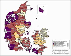
Until the development of the Danish Rural Development Programme 2007 – 2013 for the implementation of EU agricultural policy the formal definition of rural area was 'non-continuously built up areas' or 'areas with only small towns with up to 1000 inhabitants' without making any structural or functional differences.
For the demarcation of the LEADER (see p.15) areas and the preparation of the 2007 – 2013 EU programme a new classification system based on 14 indicators was developed. This classification system draws together a structural and socio-economic profile of the 98 Danish municipalities.
The classification ends up with 4 classes; Peripheral municipalities, rural municipalities, intermediate municipalities and urban municipalities. The following 14 indicators are weighted equally in the classification process:
• Population per km2
• Population in rural areas and towns with less than 1000 inhabitants
• Proportion of the municipality's area in rural zones
• Percentage employed in agricultural enterprises
• Percentage of population aged 17-64 years
• Percentage of the population aged 25-44 years
• Employment trends, 1994 – 2004
• Population trends, 1994 – 2004
• Average distance to motorway
• Jobs in proportion to employees
• Percentage of the workforce with basic education, 2005
• Percentage of the workforce with medium or tertiary education, 2005
• Average distance to areas with a high surplus of jobs, 2004
• Taxation base per capita, 2007
According to this classification the municipalities of the first two classes (peripheral and rural) could be labelled as 'rural Denmark'. However, the intermediate municipalities are also eligible for funding from EU rural policy.
A supplement to this definition of rural areas developed for the implementation of EU-policy can be found in the Danish National Spatial Planning report from 2006 where the overall urban pattern and the main transport corridors are identified. Some of the municipalities labelled as 'intermediate rural' especially in parts of Jutland in fact contain medium-sized urban centres.
 Norway
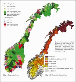
Norway does not use the term 'rural area' in its national legislation. Instead the term district is used which means 'peripheral areas consisting of a minimum of one municipality eligible for national aid in respect of transport, investment and differentiated payroll tax. Map 2 below shows this.
The two maps were drawn up by Østlandsforskning in 2004 and demonstrate another approach to classification based on the differentiation of urban and rural areas, map 1. The rural areas are further differentiated into three zones; areas with large rural towns, areas with small rural towns and areas without rural towns.
Finland
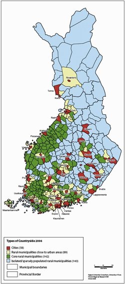 Finnish rural areas are classified into three groups: 1) rural municipalities close to urban areas, 2) core rural municipalities, and 3) sparsely populated rural municipalities. The rural categories are portrayed in the national Rural Policy Programmes in the following way:
Rural municipalities close to urban areas; these municipalities have the best development opportunities. Residents have the chance to work in nearby towns and cities. Agricultural and other businesses have highly diverse markets nearby. These economically integrated rural municipalities are located in southern and western Finland. These parts of the country enjoy the best conditions for agriculture and for the diversification of the rural economic structure.
Core rural municipalities; these are important municipalities for primary production. They also contain some rurally located sector-specific industrial centres here and there. Core rural municipalities are situated close to a number of medium-large centres. Core rural municipalities are to be found in southern and western Finland.
Sparsely populated rural municipalities; the threat to these municipalities is the cycle of poor development: depopulation, ageing population, unemployment, problems in public service provision and economic stagnation. Most sparsely populated rural municipalities are to be found in eastern or northern Finland.
 Sweden
Rural areas are, in terms of rural development policy, defined in a variety of ways. Different classifications are required, depending on what issues or problems are being analysed or what kind of action is being planned. This makes actions and analyses more accurate.
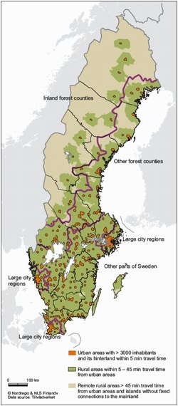
In the Rural Development Programme for Sweden 2007-2013 and in most of the regional rural strategies a definition based on accessibility is used. For more analytical purposes the Swedish Agency for Agriculture and the Agency for Rural Development have together developed a classification of rural areas based on accessibility. Three zones can be identified:
Urban areas with more than 3000 inhabitants and with a hinterland within 5 minutes travel time.
Rural areas within 5 – 45 minutes travel time from urban areas with more than 3000 inhabitants.
Remote rural areas more than 45 minutes travel time away from urban areas with more than 3000 inhabitants and islands without fixed connections to the mainland.
However within the three classes considerable differences exist in respect of preconditions and growth potentials therefore the classification is combined with a regionalisation approach which takes these different preconditions into consideration. This regionalisation approach results in the creation of the following four region categories:
Inland forest counties (Skoglänets inland)
Other forest counties (Skogslänen i övrigt)
Large city regions (Storstadsregioner)
Other parts of Sweden (Övriga Sverige)
This classification has been used in a number of national reports and studies on rural development.