THE NORTHWEST PASSAGE
The Northwest Passage has been an 'issue' since 1497 when King Henry VII of England sent John Cabot to search for a northern route to the Pacific. It took a long time, and many unsuccessful attempts, until Roald Amundsen from Norway finally succeeded in 1906. Nevertheless even thereafter it took three years to traverse the Passage in an ice-breaker ship. Indeed it was not until 1944 that a Royal Canadian Mounted Police sergeant was able to make the first single-season crossing. Since then, however, much successful traversing has been done, though heavy ice conditions remain a severe hindrance to passage through the 1450 km long passage, winding through Canada's Arctic Islands.
Due to a historical claim, Canada considers the Northwest Passage to be entirely within Canadian territorial waters. These Arctic Islands have been under Canadian control since the 1880s. Norway however claimed the Sverdrup Islands after Sverdrup returned to Norway in 1902 after being the first European to map the region. The dispute was settled in 1930 with the Canadian government paying Sverdrup $ 67 000, stating that it should be seen as compensation for the mapping efforts undertaken by the Norwegian. A similar claim was made by Norway in 1931 regarding East Greenland, leading to the 1932 occupation of the east coast between 61º30' and 63º45'. The case was brought to the Permanent Court of International Justice in The Hague which ruled in favour of Denmark.
The United States, as well as several other countries, has also argued that the Northwest Passage should be considered as 'international waters', allowing free and unhampered travel through the passage. This is based on the view that the Northwest Passage may eventually become a viable transportation route. Not only by reducing the distances travelled – in time and fuel consumption – from Europe to the Pacific region through the Panama Canal, but also by allowing ships of substantially larger dimensions than "Panamax-sized" to traverse the route.
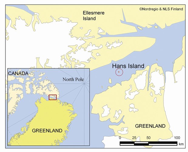
HANS Ø / HANS ISLAND
A small isolated rock, situated in icy water, and measuring 1.3 km2 has caused turmoil in the otherwise good rela-tionship between Denmark and Canada. The island was first mapped in con-nection with the British and American expeditions into the area from 1852-1876, and is supposed to have been named after a Greenlander called Hans Hendrik. The native name for the place is Suersaq, named after a man who worked as a guide and translator for the expeditions.
After a dispute with Norway regarding East Greenland, the Permanent Court of International Justice in 1933 declared the legal status of Greenland in favour of Denmark. In this decision the status of Hans Island – as well as that of the other islands surrounding Greenland – was not addressed. Denmark, has however, clai-med that geological evidence points to Hans Island being part of Greenland.
In 1973 on the other hand, Canada claimed that Hans Island was part of their territory, and no agreement has been possible between the two governments on the issue since then. Newer satellite images however show that the island is not situated within the Canadian territorial sea, but is more or less positioned right in the middle of the ocean. As a consequence Hans' Ø does not appear as Canadian territory – on the new official Canadian map of the Arctic region.
The reason for the interest shown in this small rock is founded on numerous surveys in the Nares Strait region, such as seismic and geological investigations, ice flow measures, the mapping of archaeo-logical sites, and economic surveys. Besides being important in connection with possible ship routes crossing the Arctic Ocean and using the Nares Strait as the entrance, the identification of possible energy and mineral resources adds to the level of interest in this area.
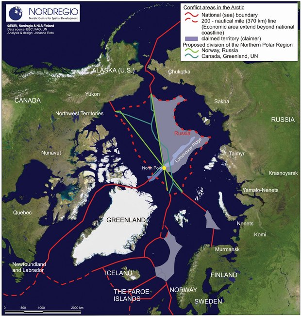
WHO OWNS THE NORTH POLE?
The North Pole has traditionally not been seen as a place of much interest. It is covered by more than 4 km of water, on top of that there are substantial amounts of ice which does not even stay intact but instead moves around with the currents in the Arctic Sea. The current raised level of interest relate however to increasing signs that below this inhospitable sea lie significant deposits of hydrocarbons – oil and gas – just waiting for recovery. So the owner of the North Pole will suddenly be in possession of this vast bounty of energy.
From a Danish perspective the question is whether the North Greenland shelf has a natural connection to the long and narrow Lomonosov Ridge. It is assumed that the Ridge is an extension of the continent, and that there should therefore be a connection to the Greenland/Canada shelf. To prove, however, that there is this natural connection it is necessary to show that the ridge actually starts somewhere in Greenland or on the Greenland continental shelf.
This can be done only if it is possible to show that there is a continuation of the materials and structures found in the ridge onto the shore, while there are different materials and structures on the two sides of this continuation. Drillings and sample taking along the supposed line would be one way of identifying both structures and materials, but such an approach would be very expensive.
In an initial attempt to seek out possible connections, the measuring of earth-quakes has been adopted as a good method of providing clarification. Tremors caused by earthquakes some-where on the globe will be recognizable even when they are very far apart, the delay of the signal will however remain very much dependent on the material it has to pass through. Therefore by measuring such signals where the expected ridge will be, and on its two sides, these signals will indicate whether the materials differ, and thus indicate the existence of a possible ridge.
A similar approach is currently being taken by Russia, with the international news gathering agencies remaining somewhat preoccupied with the fact that a Russian flag was planted on the seabed of the North Pole, some 4,261 metres below the Polar icecap. The TV-broadcast in connection with the event was part of a publicity stunt for a research project aiming at the investigation of the structure and evolution of the Earth's crust in the Arctic regions. First and foremost the part of the Arctic neighbouring Eurasia, such as the Mendeleev Ridge, the Alpha Ridge and also the Lomonosov Ridge, in order to discover whether they are linked with the Siberian shelf.
The expedition, part of the Russian programme for the 2007–2008 International Polar Year; used the Akademik Fedorov research ship and two Finnish built MIR submersibles on board, and was also assisted by the nuclear icebreaker Rossiya.
The message connected with the flag caused concern in the other countries bordering the Arctic, namely, Canada, Norway, Denmark, and the United States, as it was reported as constituting a possible claim on the North Pole as being part of Russia. It was however emphasized by the Russian authorities that the aim of the expedition was only to show that the Russian shelf stretches to the North Pole.
It is generally accepted by all of the nations involved that Arctic territorial issues can only be tackled on the basis of international law, i.e. the International Convention on the Law of the Sea. Their conclusions in respect of future disputes will however very much depend on the outcome of current research activities.
FISH AND DISPUTED WATERS
With the international agreement on a 200 nautical mile Exclusive Economic Zone (EEZ) in 1982 the issue of 'access to fisheries' was, in principle, agreed upon. Within the 200nm zone the Law of the Sea Convention gave each coastal state rights and duties in respect of the utilization and conservation of living resources within its area of jurisdiction. It is the coastal states' responsibility to determine the allowable catch, and also their responsibility to ensure that the resource endowment is not endangered by over-exploitation.
The problem is that fish move. Many fish stocks are highly migratory in nature, and often move in and out of the different zones. As such, fisheries activity outside the zone can heavily influence potentials within the limited area. This, of course, causes conflict when the influences are very marked. In both the North Atlantic and North Pacific waters this has been the case.
The Barents Sea Loophole is an area of international water in the Barents Sea, surrounded by the EEZs of Norway and Russia. The management of fisheries in this area has historically been based on bilateral agreements between Norway and Russia. But with the expansion of high sea fisheries in northern waters, it is now not only the two countries surrounding the Loophole that must be considered stakeholders in this process. Both Greenland and Iceland have also been fishing there, and both claim the right to continue to do so.
The Loop Sea is surrounded by the EEZs of Norway, Iceland, Denmark/Greenland and the Faroe Islands. The sea area is, however, outside the 200 mile EEZ of the surrounding countries, which makes it 'international waters' according to the Law of the Sea.
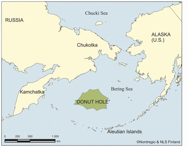
The Donut Hole in the Northern Pacific is situated in an ocean area among the richest in the North Pacific region, and indeed, in the world. The Pollock fisheries area has been registered as being among the largest in the world, and value-wise the King Crab fisheries area has massive importance for the fisheries dependent communities that use it. The Central Bering Sea is completely surrounded by Russia and the USA, but outside their 200 mile jurisdictions. The area has therefore been recognized as high seas with open access available to anyone subscribing to the Law of the Sea.
Consequently large-scale fishing of Polloch has been conducted in 'the Hole' by the United States, Russia, Japan, South Korea, China, and Poland, which eventually resulted in the depletion of the Pollock stock, thus also endangering the other species which feed on it. Until 1994 significant tension existed between the surrounding countries. In 1994 however, an agreement was signed, and enforced from December 1995, which included six contracting parties, namely, China, Japan, the Republic of Korea, Poland, the Russian Federation, and the United States.