The precise definition of “the Nordic Region” has shifted over time. This report defines the Nordic Region as all municipalities and administrative regions of the five Nordic countries (Denmark, Finland, Iceland, Norway and Sweden), as well as the Faroe Islands and Greenland (both part of the Kingdom of Denmark), and Åland (part of the Republic of Finland). This definition is consistent with that used by the Nordic Council of Ministers. It is important to recognise that there are a number of Nordic territories which are not part of the administrative systems of Nordic countries but still belong to or are administered by these countries. For example, Svalbard in Norway, Christiansø in Denmark and Northeast Greenland National Park (Kalaallit Nunaanni nuna eqqissisimatitaq) in Greenland . Though not strictly included in the national administrative systems, these territories are nonetheless included in the report when data is available.
Among the Nordic countries, Denmark, Finland (including Åland) and Sweden are three out of 28 member states in the economic and political European Union (EU). Iceland and Norway are two out of four members of EFTA (European Free Trade Association), consisting of countries, which either through EFTA or bilaterally have agreements with EU to participate in EU’s inner market. The Faroe Islands and Greenland are not members of any of these economic cooperation organisations. These differences in supra-national affiliation throughout the Nordic regions have impact on which data is included in this report. For example, the statistical institution Eurostat provides data for a number of European-wide indicators, but the geographical coverage is limited to EU, EFTA and EU candidate states, thus excluding the Faroe Islands and Greenland. Wherever possible, data for these regions has been supplemented from other sources.
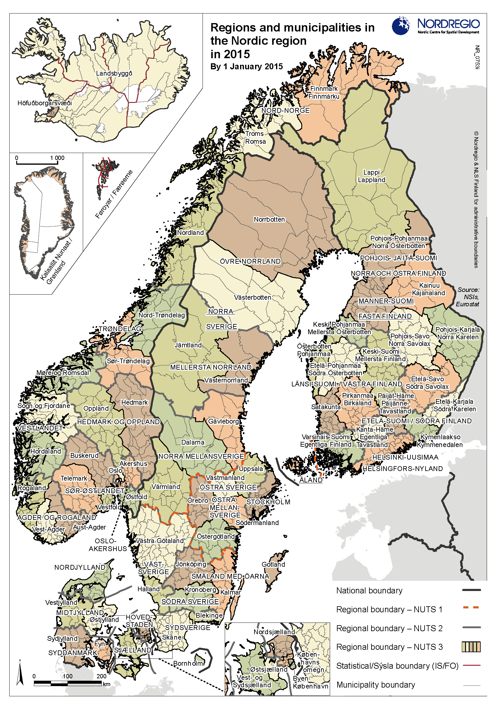
The regional dimension
This report displays data using both regional and municipal administrative divisions (see figure 1.1). As figure 1.1 demonstrates, there are large difference in size of administrative structures within the Nordic Region, both at the regional and the municipal level. The average size of a Nordic municipality is 1.065 km². The smallest municipalities are less than 10 km² and are either insular municipalities (i.a. Kvitsøy in Norway and Seltjarnarnes in Iceland) or within greater capital areas (i.e. Sundbyberg near Stockholm, Frederiksberg surrounded by the municipality of Copenhagen and Kauniainen in Finland, surrounded by the municipality of Espoo). The largest municipalities are ca. 20.000 km² and located in Northern Sweden (Kiruna and Jokkmokk). The average population density of a Nordic municipality was around 121 inhabitants per km² in 2015, with densities ranging from under 0,5 inhab./ km² (mostly in remote parts of Iceland, e.g. Fljótsdalshreppur, Árneshreppur), to just under 13.000 inhab./ km² (Frederiksberg, Denmark). Other high density municipalities include Copenhagen (6.900 inhab./ km²), Sundbyberg (5.510 inhab./ km²), Stockholm (4.880 inhab./ km²) and Solna (3.530 inhab./ km²).
The average area of a Nordic region is 17,548 km². The smallest is Oslo (455 km²), followed by two Icelandic regions, Suðurnes (884 km²) and Hövuðborgarsvæði (1.106 km²). The largest region is Norrbotten in Northern Sweden (106.211 km²), followed by Lappi-Lappland in Northern Finland (just under 100.000 km²). The average population density of a Nordic region is 65 inhabitants per km² with densities ranging from 1 inhab./ km² (Austurland, Vestfirðir, Norðurland vestra, Norðurland eystra and Suðurland – all in Iceland) and 1.423 inhab/ km² (Oslo region). Other high density regions include Hovedstaden (682 inhab/ km²) and Stockholm (318 inhab/ km²).
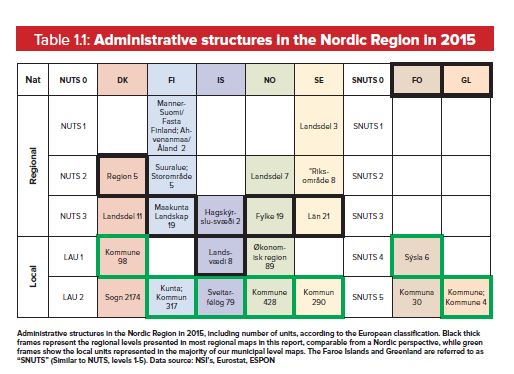
Nordic municipal and regional reforms
Patterns of administrative reforms across the Nordic Region have varied in recent years. Denmark and
Greenland saw large scale reforms in 2007 and 2009, respectively, but have had no changes in the administrative structure since then. The latest municipal boundary shifts in the Faroe Islands took place in 2009.
In Sweden, several decades have passed since the most recent, large-scale municipal reform, with no municipal mergers at all during the last decade. Finland, Iceland and Norway, however, have seen municipal or regional boundary shifts also in the most recent years, Finland both in 2015 and 2016. Maps and other figures of administrative regions and municipalities in this report are presented according their borders as of 1 January 2015.