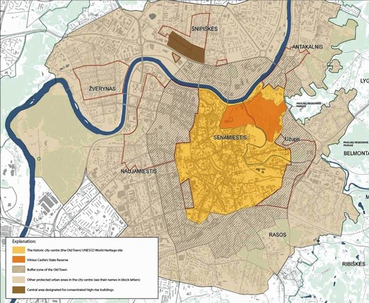
The historic city centre of Vilnius, its buffer zone and the protected urban areas
Most of the intensive urban development undertaken during the Soviet era took place away from the old town and did not really impact on the city's unique and historic environment. The new housing districts of Zirmunai, Karoliniskes, Lazdynai built in the 1970s and 1980s were, as such, successfully and unobtrusively inserted into the natural landscape. These areas also came to be showcased as 'successful urban solutions' all over the Soviet countries and, as such, were highly prized by Moscow.
A distinctive planning tradition in Vilnius can be traced back to the early 19th century when the city was the major north-west regional centre of Tsarist Russia. Since then Master Plans for the city have been regularly adopted.
The notion of 'urban hills' launched in the early 1980s by local architect A. Nasvytis is also important in this respect. The concept reflects the fact that the height of the landscape of the historic centre of Vilnius varies from 76 to 230 metres above sea-level and has become an important tool in safeguarding the distinct character of the city.
The first master plan to be developed after Lithuania gained its independence from the Soviet Union in 1991 was approved by the City Council in 1998. This plan did not have any special regulations in respect of high-rise construction.
Only a few years later, however, the first of the new generation of high-rises buildings started to rise around the Hotel Lietuva, In parallel with this the Vilnius city government, headed by the young and ambitious Mayor Arturas Zuokas was at this time eagerly engaged in creating a new and 'modern' downtown area in the Lithuanian capital.
A heated debate began and soon articles in the press and features on TV and radio found their way into the public domain, relaying all of the political wheeling and dealing. The 'Building Height Regliament for Vilnius City Central Area' developed in 2002 by Vilnius Technical University should also be included as an integral part of this debate.
In 2006 a regional conference on high-rise and heritage was organised by Vilnius municipality and the Old Town Renewal Agency – a citizen's interest group. The conference was also attended by urban planning and heritage management experts from UNESCO and from neighbouring Riga and Tallinn. (For conclusions, see separate article.)
Eventually consensus was achieved between the experts, property-developers and citizens through the new plan "The Scheme for the High-rise Constructions in Vilnius' City Centre Area", adopted in 2006.
The key feature here is that high-rise buildings are allowed on only two sites. If additional new high-rise construction is envisaged then a special plan and a comprehensive impact assessment of the urban intervention must be developed by the initiator.
Operative planning implementation also includes monitoring of the city centre's panoramas. A 3D model, a GIS database as well as a physical model of the City Centre at 1:1000 are also employed to visualise projects for new development in the existing urban and natural landscape.
Thus far some 30% of the initially planned high-rise buildings have been built in one of the designated areas, the Snipiskes district on the right bank of the River Neris while only 10% have been constructed in the other area on the western edge of the city centre.

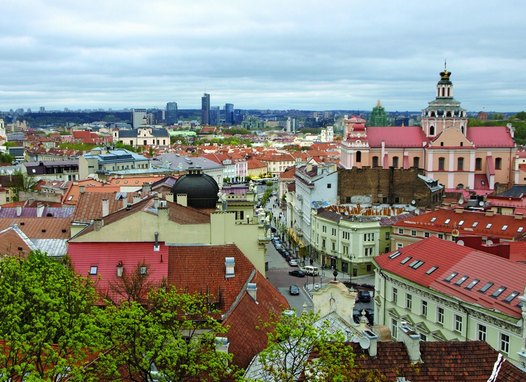
The classical tourist-image looking along Dawn Gate Street towards the high-rises at Snipiskes on the northern side of the River Neris. Photo: Gediminas Rutkauskas
By Gediminas Rutkauskas, dipl. architect, Director of Vilnius Old Town Renewal Agency