In August this year The International Boundaries Research Unit (IBRU) at Durham University (www.dur.ac.uk/ibru) published the map Maritime jurisdiction and boundaries in the Arctic. In agreement with the IBRU Journal of Nordregio on the following pages reprint the map with detailed notes.
Under the United Nations Convention on the Law of the Sea Convention (see p 24) all coastal states have rights over the resources up to 200 nautical miles from their shoreline. But some nations are able to extend their claims as a result of their landmasses - or continental shelf - extending into the sea.
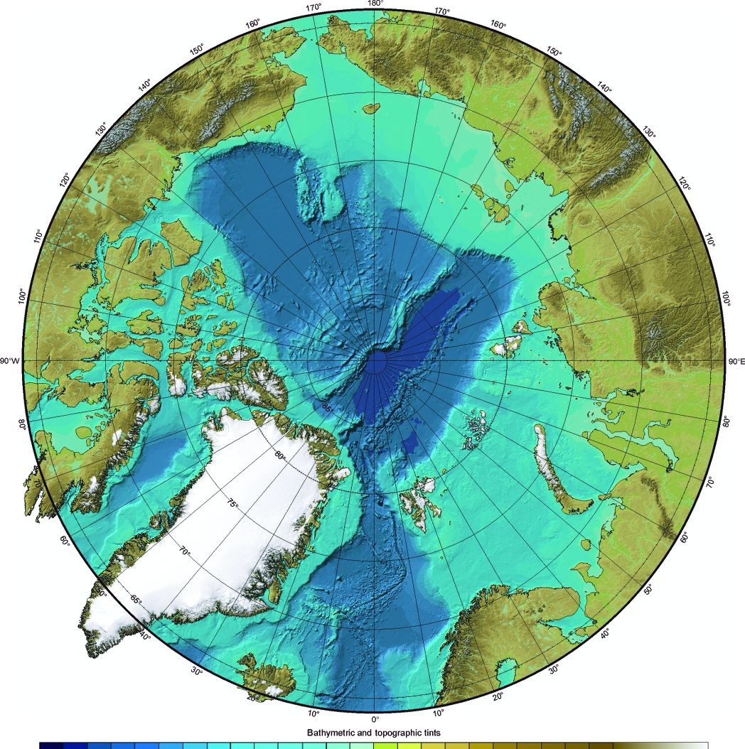
In the recent debate Russia has used the Lomonsov Ridge, stretching towards North-Greenland across the North-pole (see above) as the basis for her claims. The argument is that the Lomonsov Ridge is an extension of Russia's continental shelf. If a state can prove its rights, it can exploit the resources of the sea and the seabed within its territory. Difficulty arises in areas where more than one country submits claims because of overlapping. On the map, shown on the following pages, the researchers took into account the fact that some nations were able to extend their claims to 350 nautical miles as a result of their landmasses extending into the sea.
Martin Pratt is the Director of Research at the International Boundaries Research Unit at Durham University. He says that the nations surrounding the Arctic only have a limited amount of time to outline their claims: - If they don't define it within the timeframe set out by the UN Convention on the Law of the Sea, then it becomes part of what is known as 'The Area', which is administered by the International Seabed Authority on behalf of humanity as a whole.
Thus far seven agreements on maritime borders in the Arctic have been reached. In most cases, the states involved has been Denmark (Greenland), Iceland and Norway. The first agreement, however, was in 1973, between Canada and Denmark. Russia and USA agreed on maritime boundaries in 1990.
By Odd Iglebaek
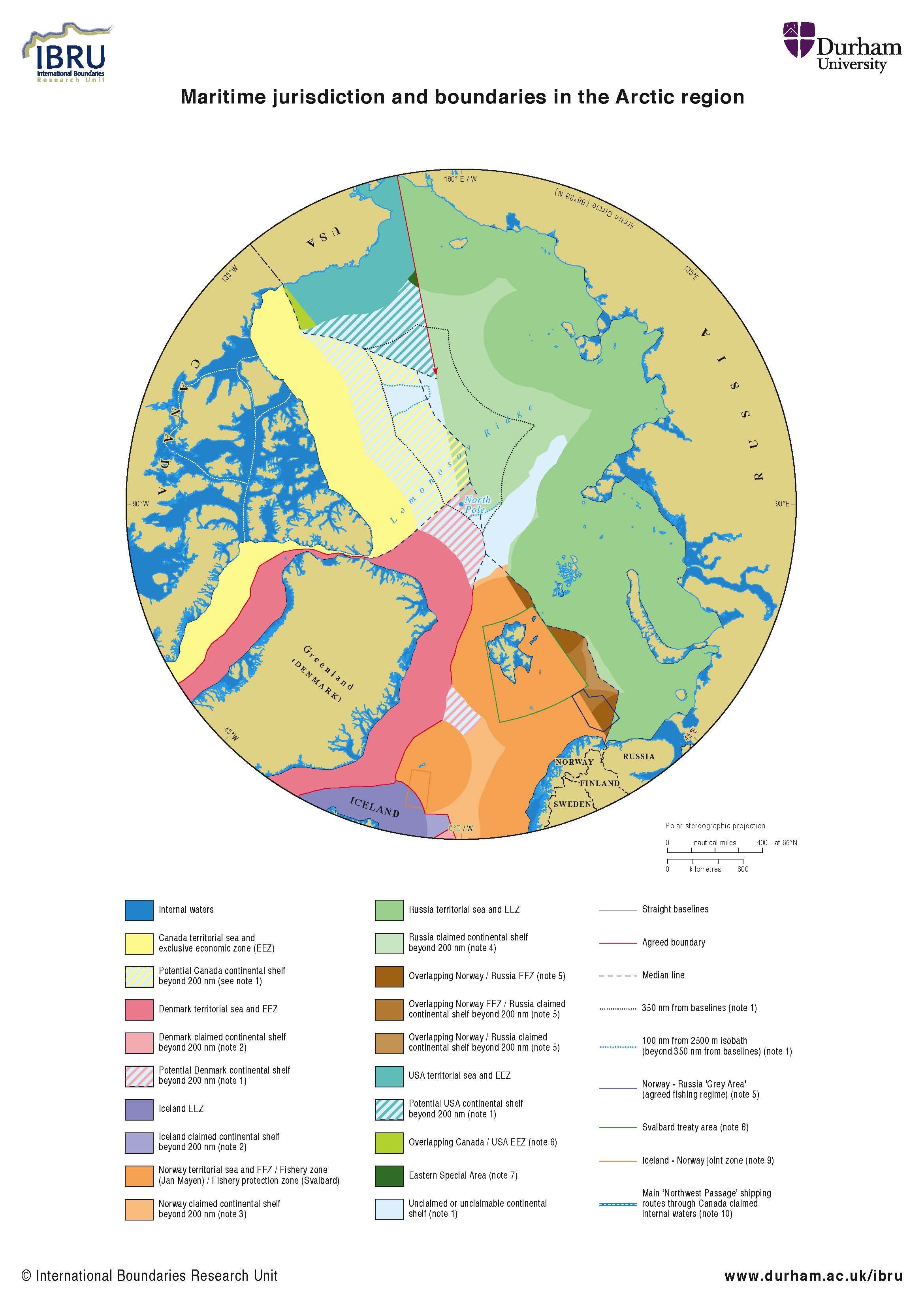
Agreed maritime boundaries
Canada-Denmark (Greenland): continental shelf boundary agreed 17 December 1973.
Denmark (Greenland)-Iceland: continental shelf and fisheries boundary agreed 11 November 1997.
Denmark (Greenland)-Norway (Jan Mayen): continental shelf and fisheries boundary agreed 18 December 1995 following adjudication by the International Court of Justice.
Denmark (Greenland) - Iceland - Norway (Jan Mayen) tripoint agreed 11 November 1997.
Denmark (Greenland) - Norway(Svalbard): continental shelf and fisheries boundary agreed 20 February 2006.
Iceland - Norway (Jan Mayen): fisheries boundary following the 200 nm limit of Iceland's EEZ agreed 28 May 1980; continental shelf boundary and joint zone agreed 22 October 1981 (see note 9).
Russia - USA: single maritime boundary agreed 1 June 1990 (see note 8).
Seabed topography
As discussed in note 1, the outer limit of the continental shelf is defined in relation to the geology and geomorphology of the continental margin. The Arctic Ocean seabed is currently rather poorly surveyed, but existing public domain datasets such as the US National Geophysical Data Center's ETOPO2 bathymetry dataset. The relief map (see p. 15) suggest that in many areas of the Arctic the outer limit of the continental shelf may fall well short of the theoretical maximum limits shown on the map on pp 16-17.
The Arctic coastal states are currently conducting hydrographic and geophysical surveys of the Arctic Ocean in order to identify the outer limits of the continental shelf with precision. Some data acquired through collaborative ventures has been made available to the public, notably the International Bathymetric Chart of the Arctic Ocean (http://www.ngdc.noaa.gov/mgg/bathymetry/arctic).
1. The depicted potential areas of continental shelf beyond 200 nautical miles (nm) for Canada, Denmark and the USA are theoretical maximum claims assuming that none of the states claims continental shelf beyond median lines with neighbouring states where maritime boundaries have not been agreed. In reality, the claimable areas may fall well short of the theoretical maximums. It is also possible that one or more states will claim areas beyond the median lines.
2. The depicted claims of Denmark and Iceland to continental shelf beyond 200 nm in the northeast Atlantic Ocean are defined in the "Agreed Minutes on the Delimitation of the Continental Shelf beyond 200 Nautical Miles between the Faroe Islands, Iceland and Norway in the Southern Part of the Banana Hole of the Northeast Atlantic" of 20 September 2006.
The agreed division of the continental shelf in this area is subject to confirmation by the Commission on the Limits of the Continental Shelf (CLCS) that there is a continuous continental shelf in the area covered by the agreement. Neither Denmark nor Iceland has yet made a submission to the CLCS.
3. An executive summary of Norway's submission to the CLCS of 27 November 2006 is available at http://www.un.org/
Depts/los/ clcs_new/submissions_files/
nor06/nor_exec_sum.pdf. The Commis-sion has yet to respond to Norway's submission.
4. Maps and coordinates defining the area covered by Russia's submission to the CLCS of 20 December 2001 are available at http://www.un.org/Depts/los/clcs_new/submissions_files/submission_rus.htm. The Commission asked Russia to revise its submission relating to its continental shelf in the Arctic Ocean.
5. Norway and the Soviet Union agreed a partial maritime boundary in Varangerfjord in 1957 but disagree on the alignment of their maritime boundary in the Barents Sea: Norway claims the boundary should follow the median line, while Russia seeks a 'sector' boundary extending due north (but deviating around the 1920 Svalbard Treaty area).
As the Barents Sea is an important fishery for both states, in January 1978 the two governments agreed on a fishing regime in the so-called "Grey Zone", a 19,475 nm² area covering 12,070 nm² of overlapping EEZ claims, 6,588 nm² of undisputed Norwegian EEZ and 817 nm² of undisputed Russian EEZ. Within the Grey Zone Norway and Russia have jurisdiction over their own fishing vessels.
6. Canada argues that the maritime boundary in the Beaufort Sea was delimited in the 1825 treaty between Great Britain and Russia defining the boundary between Alaska and the Yukon as following the 141° W meridian "as far as the frozen ocean". The USA argues that no maritime boundary has yet been defined and that the boundary should follow the median line between the two
coastlines. The area of overlap between the two claims is more than 7,000 nm².
7. The Eastern Special Area lies more than 200 nm from the baseline of the USA but less than 200 nm from the baseline of Russia. Under the June 1990 boundary agreement between the two states, the Soviet Union agreed that the USA should exercise EEZ jurisdiction within this area. A second Eastern Special Area and a Western Special Area (in which the opposite arrangement applies) were established adjacent to the boundary south of 60° north. The agreement has yet to be ratified by the Russian parliament but its provisions have been applied since 1990 through an exchange of diplomatic notes.
8. Under a treaty signed in February 1920, Norway has sovereignty over the Svalbard archipelago and all islands between latitudes 74° and 81° north and longitudes 10° and 35° east. However, citizens and companies from all treaty nations enjoy the same right of access to and residence in Svalbard. The right to fish, hunt or undertake any kind of maritime, industrial, mining or trade activity are granted to them all on equal terms.
All activity is subject to the legislation adopted by Norwegian authorities, but there may be no preferential treatment on the basis of nationality. Norway is required to protect Svalbard's natural environment and to ensure that no fortresses or naval bases are established. 39 countries are currently registered as parties to the Svalbard treaty.
9. Under the 1981 continental shelf boundary agreement between Iceland and Norway, each country is entitled to a 25% share in petroleum activities on the other's continental shelf within a 32,750 km² area between latitudes 68° N and 70° 35' N and longitudes 6° 30' W and 10° 30' W. The idea of a joint development zone straddling the boundary was proposed by a conciliation commission set up by the two governments when they were unable to reach a negotiated boundary settlement. The continental shelf boundary itself is located 200 nm from the coast of Iceland but less than 100 nm from Jan Mayen, reflecting the significant disparity in the lengths of the relevant coastal fronts (more than 18:1 in Iceland's favour).
10. Canada claims that the waters of its Arctic archipelago are historic internal waters, and has enclosed them within a system of straight baselines. Under normal circumstances there is no automatic right of innocent passage through internal waters for foreign ships. However, other states (particularly the USA) argue that the channels in the archipelago which form part of the 'Northwest Passage' through the Arctic qualify as straits used for international navigation under Part III of UNCLOS, and that there is therefore a right of transit passage through the straits for foreign ships.
While the Northwest Passage was under permanent ice cover, the debate was largely academic - but with the polar ice cap retreating and the Passage becoming increasingly navigable, the question of which legal regime applies has become increasingly pressing. Similar issues affect the straits of the 'Northeast Passage' around Russia's Arctic coastline.