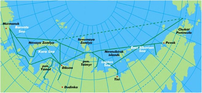
Figure 1: Map of the Northern Sea Route Source: Murmansk Shipping Company homepage
Nevertheless, even when taking into account the additional fuel needed when sailing in icy waters the basic fuel saving (and thereby also the saving in respect of emissions) remains enormous. The shorter distance also means shorter transit times. This is a benefit for both the user, as the goods spend less time in transit, and the ship-owners can make the ship undertake more roundtrips per year.
The increased cost of building ice-classed ships, the unpredictability of open waters, slower speeds, navigation difficulties, the greater risk involved and the availability of ice-breaker services are all factors influencing the total expenditure calculations. The Depart-ment of Maritime Research and Innovation at the University of Southern Denmark has studied the economic feasibility of the Northern Sea Route. A summary of their findings is provided below.
The Northern Sea Route crosses five Arctic Seas: the Barents Sea, the Kara Sea, the Laptev Sea, the East Siberian Sea and the Chukchi Sea. The distance travelled on this route will be between 2,100 and 2,900 nautical miles depending on prevailing conditions, and will become the shortest seaway connection between Northeast Asia and Northern Europe (See Figure 1.)
 Historically, foreign ships have been prevented from using the Northern Sea Route. In October 1987 however, then the Soviet leader Michael Gorbachev delivered a speech in Murmansk declaring that the Northern Sea Route would be opened to international traffic. This was followed up in 1991, by the Russian Federation, which approved Regulations for Navigation of the Seaways along the Northern Sea Route – ensuring free shipping, without discrimination, for all vessels for commercial purposes along the Russian Northern Coast.
The Arctic however still has an important role to play in the national security system of the Russian Federation. Actually all operations along the NSR, including scheduling, route assignment, navigational support, use of pilots etc., are controlled by two Russian Marine Operations Headquarters (MOHQs). The formerly state-owned Murmansk Shipping Company serves as the MOHQ at the western end, and Far Eastern Shipping Company is in charge of the traffic originating at the eastern end.
Climate Change and Ice Conditions
The navigation season of the Northern Sea Route is often defined as the number of days per year with less than 50 % sea-ice cover. In 2004, the length of the season was projected to increase from 20 - 30 days per year to 90 - 100 days per year by 2080. This estimate might however be too conservative as the melting of sea ice increased dramatically between 2004 and 2007 and it seems likely to set a new "record" again this year.
The Northern Sea Route is a fairly long shipping lane and the climatic conditions are not stable along the entire route. The amount of ice usually varies more in the eastern as compared to the western sectors, and of course changes from one year to the next.
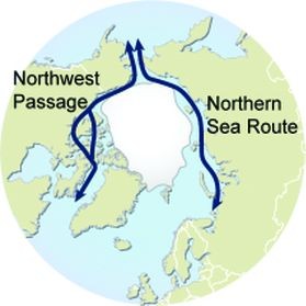
It could easily be that in some years the Northwest Passage is virtually ice-free while the Northeast Passage is not (and vice versa). As such, the Northern Sea Route would potentially change from year to year. For shipping this prevailing unpre-dictability due to the natural conditions remains the main problem with regard to commercial use of the Arctic sea ways.
One of the most important factors in container shipping is regularity - especially when calling at major international ports with significant capacity constraints. Both the NSR and the Northwest Passage however exhibit a number of factors with a potentially significant impact on regularity. The Arctic Ocean remains quite a harsh environment while the fundamentally unpredictable ice conditions can make it difficult to maintain a regular schedule.
Icebreaking Fees
The icebreaking assistant is one of the major cost components of sailing the Northern Sea Route. The fees are dependent on the vessel's size, ice class, the route and the level of support required. In addition to the actual icebreaking, the fees also include guiding by reconnaissance aircraft, hydrographic and meteorological services and the use of communication systems.
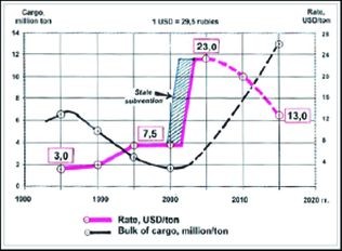
In the early 1990's, when the cargo volume along the Northern Sea Route was around 4 million tons per year, the average ice-breaking fee was US$ 2-4 per ton. In the late 1990's, when the volume dropped to 2.5-2.8 million tons per year, the operation became unprofitable and the rate was increased up to US$ 7.5 per ton. At this point, the Russian government annually granted additional subsidies to maintain the icebreaker fleet.
In 2003 these subsidies ceased to be granted. The fee for icebreaking was therefore increased to an average of US$ 23 per ton – in order to maintain and modernize the icebreakers. The changes in fees are shown in Figure 2.
Figure 2: Annual revenue comparison
An up to date list of current icebreaking fees is not easily obtained. However, 1,050 RUB (US$ 40.8) per ton of containerized cargo was mentioned in a recent tele-phone conversation with the Murmansk Shipping Company. They would consider one TEU (container) as 24 tons and the total icebreaking fee for one TEU could be equivalent to US$ 979.2. This is extremely high as compared to other cost components.
In the future, it seems likely that the rates will, in the main, be influenced by the amount of cargo, the financial resources available to maintain the ice breakers and most importantly, by the broader sweep of Russian Arctic policy and the desire to introduce the market mechanism into this route.
The Northwest Passage
The alternative to the Northern Sea Route for shipping through the Arctic Ocean is the Northwest Passage. From a navigational point of view, however, this route is more difficult as it passes through much narrower straits.
Both lanes are, from an international shipping point of view, immature. The North West Passage thus far has none of the administrative procedures and perhaps more importantly a wholly insufficient icebreaking capacity. The Northen Sea Route (the North East Passage) has some administrative procedures but no guaranties in respect of the time needed to complete these administrative processes. On the other hand it has the world's largest icebreaker fleet at its disposal.
If the routes between Europe and Asia have to use the North West Passage ships must sail though the David Strait and to the south of Greenland before crossing the Atlantic Ocean - a detour of approximately 2000 nautical miles as compared to the NSR. Whether or not crossing through the North West Passage will be feasible will of course depend upon the fees associated with using such a connection. What such expenditures are likely to entail will be the topic of a forthcoming research project at the Department of Maritime Research and Innovation.
The Case Study
In the economic feasibility study, two sets of 4,300 TEU container ships (one non ice-classed and one ice-classed, both making year round service between Asia and Europe) are deployed. The annual profit gained from a regular service by the non ice-classed ships via the Suez Canal is compared to the annual profit gained from the ice-classed ship, using the Northern Sea Route during the navigable months and the Suez Canal for the rest of the year.
The study looks into the main factors influencing the NSR, the two most important ones being the navigable time and the icebreaking fees. Three options for navigable time (3, 6, 9 months per year) and three options for icebreaking fees (the fee will be reduced by 50%, 85% and 100%) are used.
These options are combined with each other to make a 3 x 3 matrix showing different scenarios. An overall comparison is then made to evaluate whether, and under which conditions, the Northern Sea Route is competitive against the traditional route via the Suez Canal.
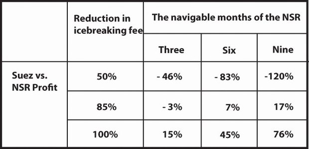
The total one-way transit time for each of the two routes is first calculated depending on distance, speed, waiting time etc. Based on this, the numbers of trips per year are obtained and finally the annual revenue, overall cost and annual profit are calculated and compared. The main results are shown in Table 1.
Table 1: The dramatic changes of averaged NORTHERN SEA ROUTE icebreaking fees from 1985 to 2003 (tonnage due) Source: Legal and administrative issues of arctic transportation, GROWTH project GRD2-2000-0112 "ARCOP", Finland.
As can be seen from the table above, even if the ice breaking fee is reduced by 50%, the NSR is still not economically viable as compared to the Suez Canal Route, no matter how many months it will be navigable. If the ice breaking fee is reduced by 85%, it still does not make the route competitive when it is open for only three months, but if it is open for longer it would generate more profit than use of the Suez Canal Route.
If however use of the NSR is free of charge, it is competitive in all scenarios and it generates up to 76% more profit than the Suez Canal Route if the NSR was navigable for nine months.
More general information and the detailed calculations used to produce these results can be obtained from the authors.


By: Jacob Kronbak Associate Professor, Department of Maritime Research and Innovation, University of Southern Denmark
Miaojia Liu Assistant Professor, Center for Maritime Economics and Logistics (MEL), Erasmus University Rotterdam